![](/images/other/stat-length.png)
![Trail Walking Le Monêtier-les-Bains - Roche Robert en boucle - Photo](https://media.geolcdn.com/t/1900/400/5bf621bd-9226-42f8-8987-e014c226a7bc.jpg&format=pjpeg&maxdim=2)
Roche Robert en boucle
GuyVachet
User
![Length](/images/other/stat-length.png)
![Max alt](https://static1.geolcdn.com/siteimages/upload/files/1508320355ic_sort_altitude_max_24dp.png)
![Uphill gradient](https://static1.geolcdn.com/siteimages/upload/files/1508320355ic_sort_den_pos_24dp.png)
![Km-Effort](/images/other/stat-length.png)
![Min alt](https://static1.geolcdn.com/siteimages/upload/files/1508320355ic_sort_altitude_min_24dp.png)
![Downhill gradient](https://static1.geolcdn.com/siteimages/upload/files/1508320355ic_sort_den_neg_24dp.png)
![Boucle](https://static1.geolcdn.com/siteimages/upload/files/16400158638029165_repeat_loop_refresh_sync_direction_icon.png)
![Walking](https://static1.geolcdn.com/sitytour/trail-icons/101.png)
3h34
Difficulty : Difficult
![Scan this QR Code to open this trail in the SityTrail application](https://capi.geolives.com/qq0zvz2zws4bq2lad0pu/sitytour/trails/4144934/qr.png?size=200)
FREE GPS app for hiking
About
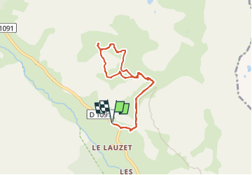
Trail Walking of 7.3 km to be discovered at Provence-Alpes-Côte d'Azur, Hautes-Alpes, Le Monêtier-les-Bains. This trail is proposed by GuyVachet.
Description
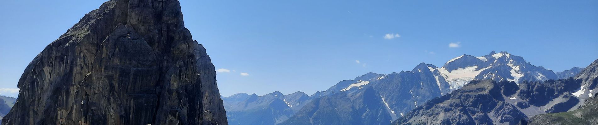
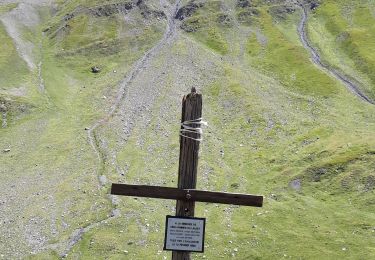
Circuit relativement sauvage qui permet d’admirer la Roche sous toutes ses faces et en offrant des vues sur les Ecrins. La rando commence par la classique montée jusqu'à l'Alpe du Lauzet. Le sentier monte sur la croupe et la suite dans le vallon demande de l'attention pour arriver au pied de la falaise. Il faut un peu d'intuition pour cheminer avant de ressortir sur la crête herbeuse qui permet de prendre un peu de recul pour mieux apprécier la vue de La Meije aux Agneaux, d'un côté et les Arêtes de la Bruyère avec la descente du Grand Lac de l'autre. Le retour est plus sauvage surtout si on veut éviter une grande boucle qui passerait au milieu des troupeaux, il faut naviguer entre des parties humides et les multiples drayes qui s’interrompent régulièrement. Puis l'itinéraire retrouve celui de montée pour revenir au point de départ.
Positioning
Comments
Trails nearby
![Trail Walking Le Monêtier-les-Bains - Le Grand Lac - Photo](https://media.geolcdn.com/t/375/260/ext.jpg?maxdim=2&url=https%3A%2F%2Fservices.sitytrail.com%2FGeolivesWS%2FDownloadMedia.ashx%3FTrailID%3D101251%26Media%3D741_2.jpg)
![Walking Walking](https://static1.geolcdn.com/sitytour/trail-icons/101.png)
Walking
![](/images/other/stat-length.png)
![](https://static1.geolcdn.com/siteimages/upload/files/16400158638029165_repeat_loop_refresh_sync_direction_icon.png)
![Trail Touring skiing Le Monêtier-les-Bains - La pointe de L'etandard - Photo](https://media.geolcdn.com/t/375/260/b38baca5-df4e-43d2-ad4d-62353ec9c6be.jpg&format=jpg&maxdim=2)
![Touring skiing Touring skiing](https://static1.geolcdn.com/sitytour/trail-icons/503.png)
Touring skiing
![](/images/other/stat-length.png)
![](https://static1.geolcdn.com/siteimages/upload/files/16400158638029165_repeat_loop_refresh_sync_direction_icon.png)
![Trail Touring skiing Villar-d'Arêne - Roc noir de Combeynot - Photo](https://media.geolcdn.com/t/375/260/31d3bf16-d2df-42fc-9fef-f746677c1101.jpg&format=jpg&maxdim=2)
![Touring skiing Touring skiing](https://static1.geolcdn.com/sitytour/trail-icons/503.png)
Touring skiing
![](/images/other/stat-length.png)
![](https://static1.geolcdn.com/siteimages/upload/files/16400158638029165_repeat_loop_refresh_sync_direction_icon.png)
![Trail Walking Le Monêtier-les-Bains - 05 col ponsonniere - Photo](https://media.geolcdn.com/t/375/260/732cfff8-bdda-413d-a875-cbedcd33e096.jpg&format=jpg&maxdim=2)
![Walking Walking](https://static1.geolcdn.com/sitytour/trail-icons/101.png)
Walking
![](/images/other/stat-length.png)
![](https://static1.geolcdn.com/siteimages/upload/files/16400158638029165_repeat_loop_refresh_sync_direction_icon.png)
![Trail Walking Le Monêtier-les-Bains - Pic Blanc du Galibier - Photo](https://media.geolcdn.com/t/375/260/50ed979f-f708-4034-9dd2-18865bd9cea5.jpg&format=jpg&maxdim=2)
![Walking Walking](https://static1.geolcdn.com/sitytour/trail-icons/101.png)
Walking
![](/images/other/stat-length.png)
![](https://static1.geolcdn.com/siteimages/upload/files/16400158638029165_repeat_loop_refresh_sync_direction_icon.png)
![Trail Walking Le Monêtier-les-Bains - pic est de Combeynot - Photo](https://media.geolcdn.com/t/375/260/eafe3cfc-88ad-4ef2-8553-fd5f300cfc38.jpg&format=jpg&maxdim=2)
![Walking Walking](https://static1.geolcdn.com/sitytour/trail-icons/101.png)
Walking
![](/images/other/stat-length.png)
![](https://static1.geolcdn.com/siteimages/upload/files/16400158638029165_repeat_loop_refresh_sync_direction_icon.png)
![Trail Walking Le Monêtier-les-Bains - l'aiguillette du Lauzet par le grand lac - Photo](https://media.geolcdn.com/t/375/260/047d899e-dac4-4227-82df-970b78e389f9.jpg&format=jpg&maxdim=2)
![Walking Walking](https://static1.geolcdn.com/sitytour/trail-icons/101.png)
Walking
![](/images/other/stat-length.png)
![](https://static1.geolcdn.com/siteimages/upload/files/16400158638029165_repeat_loop_refresh_sync_direction_icon.png)
![Trail Walking Le Monêtier-les-Bains - Chalet de l'Alpe - Grand lac - Croix 15/08/18 - Photo](https://media.geolcdn.com/t/375/260/7c37172e-8a7f-4341-9586-916674aea659.jpg&format=jpg&maxdim=2)
![Walking Walking](https://static1.geolcdn.com/sitytour/trail-icons/101.png)
Walking
![](/images/other/stat-length.png)
![](https://static1.geolcdn.com/siteimages/upload/files/16400158638029165_repeat_loop_refresh_sync_direction_icon.png)
![Trail Via ferrata Le Monêtier-les-Bains - Via ferrata Aiguillette du Lauzet 30/06/18 - Photo](https://media.geolcdn.com/t/375/260/f94c7ee2-184f-466f-9471-9131d6d51143.jpg&format=jpg&maxdim=2)
![Via ferrata Via ferrata](https://static1.geolcdn.com/sitytour/trail-icons/902.png)
Via ferrata
![](/images/other/stat-length.png)
![](https://static1.geolcdn.com/siteimages/upload/files/16400158638029165_repeat_loop_refresh_sync_direction_icon.png)